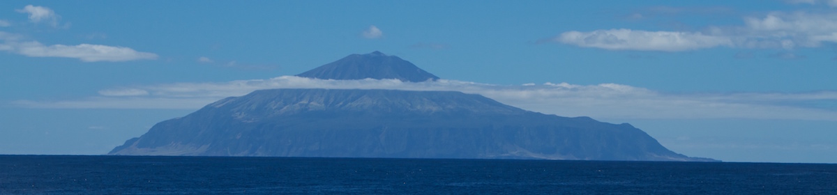
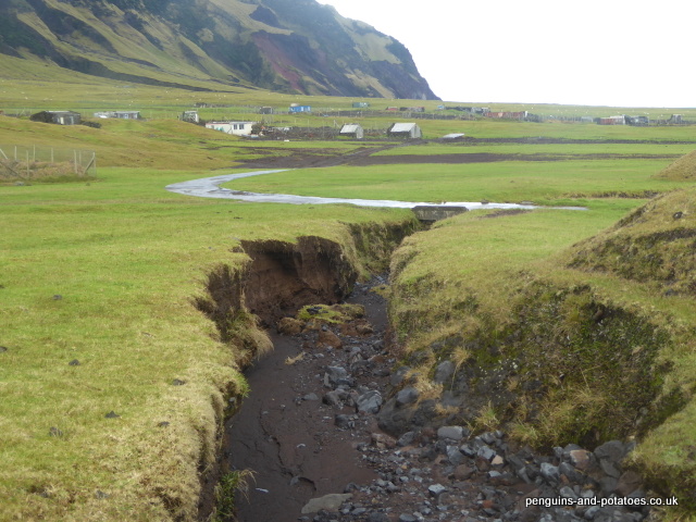
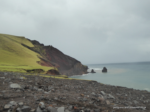
In the region of 200,000 years ago, one single volcano spewed billions of tons of rock out from the floor of the South Atlantic, and the island of Tristan da Cunha was formed. From the very time that the classic cone-shape was formed, the forces of nature began to beat and weather the newly emerged volcanic rock. Rain would be the main agent to erode the rock face, and the softer rock would erode most easily. At the same time, all around the shore the constant action of wave impacts would cause sea erosion. Year after year the process of erosion would continue, and year after year material eroded from the high ground would be deposited on the coastal fringes. Bit by bit the coastal plains would be built up with boulders, stone and grit from the high ground. Thus, over the years, the coastal plains would be formed, the biggest of which of course is the Settlement Plain. The plain is full of evidence of boulders and other material coming down from the high ground, reflecting years of particularly heavy rain. At the same time the rock and grit deposits on the plain would themselves be eroded by huge streams of water, cutting out the gullies and taking the deposits down to the sea.
It is clear that some years this process of erosion and deposition is relatively gentle, but some years the rain is unusually heavy and the erosion action of the rain is unusually high. Either because of the normal cyclical nature of weather patterns or perhaps because of global warming, we have seen very heavy rain in recent years. Last year we saw the land-slip across the road leading to The Valley being formed. This year, we have seen the worst floods and flood damage in living memory.
It all started, really, on April 14th. On that day there was continuous very heavy rain for a long time. The waterfalls were all in full force, the watrons (streams) were running hard, and people either kept indoors or went out in wellies. The gritty soil and sub-soil on the island drains very freely, and by the following day the signs of flooding were starting to disappear. Then came the night of the 17th / 18th. Falling on ground that was already waterlogged, very heavy continuous rain caused storm damage of biblical proportions.
In the middle of the night, it became apparent that action was necessary to save properties that were being threatened by the flood. The Settlement street lights were switched on, and a small team of ‘action men’ turned out with a JCB, diverting rivers of water from the houses, particularly to the east of the settlement where the Big Watron was substantially overflowing its banks.
The following day, and for a number of weeks, damage repair work was carried out on a priority basis. Help was given to some householders whose homes had been flooded. Gates were put up to take the place of cattle grids, which had been filled to the top with stone and silt. Also, the PWD (Public Works Department) turned out in force, partly to cut some sort of a roadway through the massive new fields of stone and grit, and partly to make temporary repairs to the erosion that had taken place in some of the gullies.
In the two days of heavy rain, 132mm of rain fell. This is not in itself a phenomenal amount of rain, but it comes after a very wet year. Already this year, five months in, we have had over three-quarters of the annual rainfall average
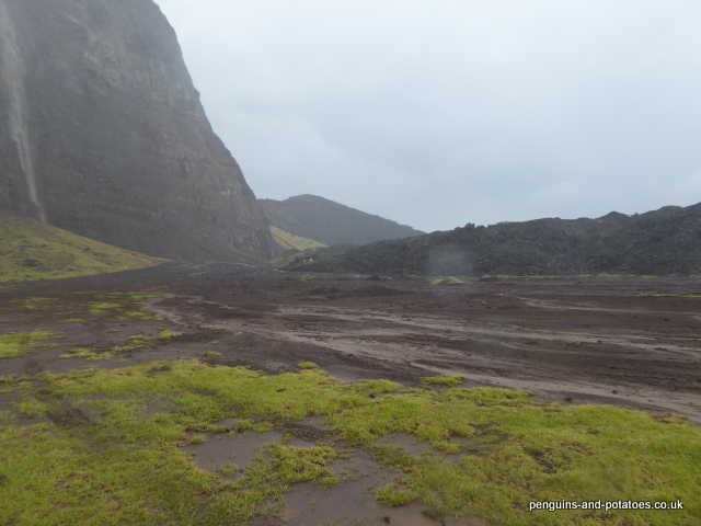
One of the of the questions that this emergency has raised is to try and find out the overall reason for so much land material being swept off the Base (The Base is the high land, running up from the top of the coastal cliffs right up to the Peak), because the main part of the damage done has been caused by alluvial deposits, rather than simply running water. It is clear that considerable erosion is taking place on the Base. Even some weeks after this awful event, when a heavy rain caused the waterfalls to run it was clear that there were white waterfalls and brown waterfalls. The brown waterfalls evidently had very heavy loads of silt and stone being washed off the Base. The unanswerable questions that need to be asked are along the lines of :- Is this amount of erosion simply a consequence of very heavy rain? Are we seeing increased rainfall as a result of global warming? Are there environmental reasons for this high level of soil erosion, and in particular is there a possibility that grazing by sheep has exposed the soil on the base to increased weathering? It will be very difficult to obtain factual evidence to support any particular theory, since there is a lack of survey information that measures, analyses and describes the situation on the Base, and access at the moment is dangerous and highly restricted. If we had a resident helicopter the task would be easier!
The damage that has been done can be divided into the following categories:-
- House flooding. Individual householders have been faced with flooded homes. Some carpets have been ruined, and the drying-out process has caused hardship to individual families
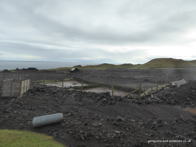
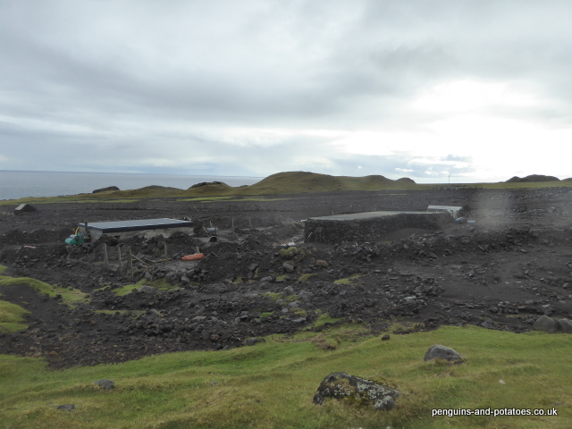
- Cattle grids. Three cattle grids have been filled to the top with silt, rendering them totally ineffective – cattle can walk across them with ease. As a result, a new gate has been installed in one case, and in two cases cattle have had to be moved from their normal pastures because they can no longer be retained by the cattle grids. The Agriculture Department is faced with the task of rebuilding these cattle grids.
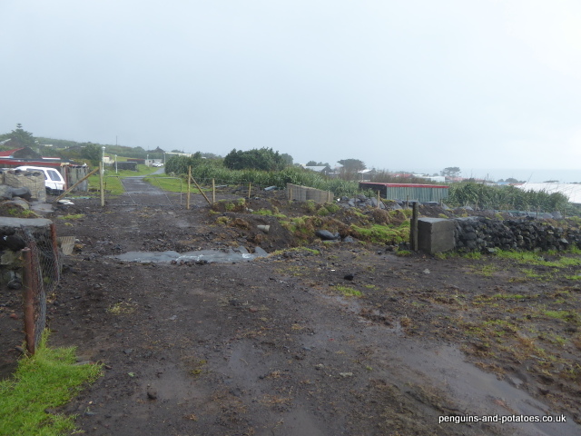
- The road system has suffered greatly. Within the Settlement there is considerable evidence of the road structure being weakened and eroded. On the road to the Patches, there are whole lengths where the road has been completely washed out. In other sections, new potholes have been formed, and there is plenty of evidence of erosion causing further damage and vulnerability.
- Water troughs. Silt has been washed down the hill, in one case completely burying a cattle drinking trough.
- It is believed that around 12 sheep were washed out to sea by the floods, and one dead cow has been found half buried in the stone and grit deposits. It is assumed that these animals were sheltering in the gullies when they were overcome by the water.
- Gully road crossings. Three gullies on the road to the Patches were deeply eroded, making them impassable to any vehicle. PWD rapidly sent out excavators, and quick repairs were made by constructing barriers of boulders on the lower side of the crossings (known as ‘rip-rap’ to land engineers) and infilling with silt and gravel in order to make the crossings usable.
- Land slips. These are probably better described as alluvial fan deltas, rather than land slips, since they have been formed by water-borne boulders, stones and silt being washed down from the high ground and progressively being deposited on the slopes as the flowing water lost its momentum, rather than the mountainside slipping away en masse and being deposited on the plain. The area and volume of the land slip which was formed last year increased considerably – perhaps its volume trebled. But the main devastation was caused by an entirely new slip or delta that swept down from the area of the Base that feeds Wash Gulch and which covered an area of about 70 acres. The grazing area that this slip covers, together with a number of smaller deposits, are now of no use at all to our grazing cattle.
- Potato patches. The Red Body Hill Potato Patches have essentially been destroyed by the new land slip described in the above paragraph. Some 15 – 20 Patches are lost. It remains to be seen whether anything can be done to restore these areas, or whether these Patches are lost for ever. What is certain is that if the island embarks on any programme to recover these potato growing areas, the work will be difficult, time-consuming and expensive.
- While in some areas valuable pasture land has been covered up by silt and stone, in other areas erosion has removed pasture and washed it away. For example, large areas of the seaward side of Hill Piece have been lost by erosion, before and after photographs showing the extent of the loss of grazing land. Meanwhile the sides of all the gullies have been eroded by the force of water, and more grazing land has been lost in these areas.
The people of Tristan da Cunha are known for being able to respond to natural calamities in a pragmatic, practical and co-ordinated way. That has already been evident with the works carried out in the last weeks since the floods. During the coming months, a wide range of works will be carried out as part of the flood recovery effort. However, there is one aspect of island life and the island economy that will take a severe beating from this flood calamity, and that is the situation with the cattle. It is well established and well recorded that there has been substantial overgrazing by cattle for very many years. The overgrazing problem, simply caused by having too many cattle for the land resources available, has all of a sudden been made very much worse by the flood damage. The approach into winter is the very worst time for the island to suffer a reduction in the grazing surface of around 10 – 12%. The Agriculture Department is making all effort to minimise the impact of the flood related problems, but it is felt that there is increasing awareness of the strategic danger of having too many cattle for the carrying capacity of the land.
June 24, 2017
Alasdair,
We were so sorry to read about the terrible flooding you’ve had! Hopefully things will improve with time and mother nature’s cooperation.
We’re off in the morning to San Diego to house and pet sit for Heather & family. She’s feeling “good” and obtained doctor’s okay to do the Danube cruise. We’re keeping our fingers crossed that all works out. Two days after they return home, she begins experimental drug immunotherapy. She can no longer have chemo due to extensive scar tissue.
Stay well and lots of love to you and Barbara.
Vicki & Dick
Hello to you both!
Flooding of that magnitude must be devastating for such a small community. We do hope that things are on a more even keel now.
We are in the middle of a heat wave, and consequent water shortage! The canal is still open on our cruising section but only just. This will be our last season of cruising with guests, next year, cruising for us! All the very best to you both, often think of you. XX
We are a group of volunteers and opening a new scheme in our community. Your website offered us with valuable information to work on. You have done a formidable job and our entire community will be thankful to you.